|
Geographic
Overview and Ecosystem Characteristics:
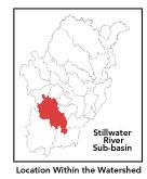
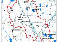
Most of this subbasin1
lies primarily in the communities of Sterling, Princeton and West
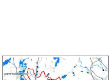
Boylston with parts extending into Holden, Leominster, and Westminster.
Located in the "fuzzy" zone encompassing parts of both
the Upper Worcester Plateau and the Southern New England Coastal
Plains and Hills ecoregions2
of central Massachusetts, this area drains into the Wachusett Reservoir:
the largest body of open water in the greater Nashua River watershed.
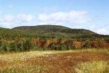
Topography is generally hilly, encompassing numerous
flatter wetlands, broad valleys, and floodplains. This subbasin
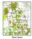
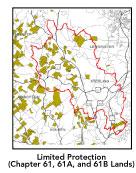
has a large amount (49%) of permanently protected undeveloped open
space owned by Metropolitan District Commission (MDC), the municipalities,
and others: particularly along the lower Stillwater. Another significant
portion of private lands are classified as Chapter 61, 61A or 61B.*
A low percentage (less than 8%) of total impervious
surfaces3 -- namely, paved areas
such as streets, driveways, and parking lots-- for this whole subbasin
indicates that concerns of compromised stormwater and other non-point
sources4 of contaminants (for example:
pesticides, fertilizers, oils, asphalt, pet wastes, salt, sediment,
human litter and other debris) is not a pressing concern. As the
Stillwater watershed becomes increasingly developed, there will
be more threat of water quality deterioration from risks associated
with urbanization, including thermal pollution, over-fertilization
of lawns, improper handling of hazardous wastes, septic system leachate,
street runoff, and the like.
back
to top
Land Ownership and
Land Use5
Patterns: The land-use pattern is predominantly
undeveloped forest (hardwood mixed with softwood) or wetland plus
low-density residential settlement in the hilly upland areas. Concentrated
settlements and strip developments are located near town centers
and along major roads. Heavily traveled Interstate 190 runs through
this subbasin. The highway which connects Worcester and Leominster
has led to and will continue to lead to increased development pressures,
primarily of single-family residences. Agriculture (notably "hobby
farms" and backyard horse paddocks), commercial operations,
industry and other developed land uses are less significant. However,
sand and gravel extraction operations are contributing to sedimentation
and land use change.
back to top
Major Water Resource
Issues: Streamflow, as in most of New
England, has significant seasonal changes6.
Existing flows for the Stillwater River are considered to be under
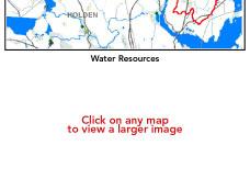
"medium stress". The Stillwater River system is an important
water supply (that is, overlying a major aquifer). The River - and
the very extensive wetland system bordering it-- feeds the Wachusett
Reservoir (12% of the reservoir's total) and is in turn fed by numerous
streams including: Ball, Babcock, Bailey, Connelley, East Wachusett,
Houghton, Keyes, Rocky, Scanlon, Washacum and Wilder. There
are no wastewater treatment plants nor NPDES permitees in this subbasin.
The majority of residents have on-site septic systems although a
number of homes will be serviced by the new Holden-West Boylston
Sewer Project.7
As for specific areas of concern, there is streambank
erosion along Crowley Road in Sterling which can lead to siltation/sediment
deposition, higher instream temperatures, and threatened habitat.
Further, Bartlett Pond in Leominster, and the Quag and Stuart Pond
in Sterling are eutrophic and are heavily vegetated with noxious*
plants. East Wachusett Brook in Princeton-Sterling is considered
to only partially support recreation due to high bacteria (fecal
coliforms) during both wet and dry conditions; otherwise, it has
high quality habitat and limited disturbance. Waushacum Brook, however,
is considered a "moderately septic polluted stream".
On a positive note, Justice Brook in Sterling
is very clean and has particularly low bacteria levels. The River
and several of its tributaries are stocked with trout and self-reproducing
populations of native brook trout are found throughout the subbasin.
According to the 1998 Nashua River Watershed Report Card, the Stillwater
is rated as on alert8
for aquatic habitat. Beavers, on the other hand, have capitalized
on the present environmental conditions and proliferated to the
point of being considered a "nuisance" species*.
The most serious damage beavers are causing in this subbasin, in
addition to increased localized flooding behind their dams, is from
bacterial contamination of wellwater. There are no 303(d)-listed
impaired water bodies in this subbasin.
back to top
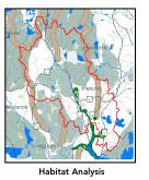
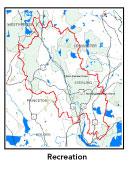
Recreation and
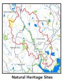
Priority Habitat Areas: Keyes Brook, a
tributary to the Stillwater running northwest from West Sterling,
is part of the MA Natural Heritage and Endangered Species Program
Priority Habitat area that connects down the Stillwater all the
way to Wachusett Reservoir and is habitat for numerous listed turtle
species. The area is not without some development, yet it is an
important connector between the extensive habitat of focus areas
to the northwest (Bartlett Swamp, Wachusett Mt. State Reservation,
and Leominster State Forest) and southwest (Poutwater Wildlife Management
Area in the Quinapoxet subbasin). Protection priorities should focus
on Hy-Crest Pond area and south of Justice Hill Road.9
back to top
Resource Protection
Goals and Recommended Actions
GOAL: Protect wildlife habitat
and migration corridors in the subbasin.
- Assist MDC, MassWildlife, other state agencies,
municipalities, and local land trusts in consensual transactions
to acquire additional open space in priority areas especially
in Hy-crest Pond to south of Justice Hill Road area.
- Sponsor local events to raise public understanding
about native wildlife and the impacts of development patterns
on ecosystem and habitat integrity.
- Work with local conservation commissions to gain
their backing for natural resource/ habitat inventories.
- Continue MDC — Division of Watershed Management's
Private Land Forestry program which encourages private forest
landowners to adopt forestry practices — namely, forest management
planning required by the Chapter 61 program — that protect
water quality.
- Encourage citizen certification of vernal pools.
GOAL: Protect high-priority open space, vistas,
and community character in the subbasin.
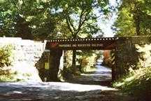
- Assure continued commitment from MDC to
using Stillwater Farm as an educational resource for watershed
protection as well as a eco-tourist destination.
- Encourage the use of MA Executive Order 418* funding
for "Open Space and Resource Protection Plans" for each
Massachusetts community in the Stillwater River subbasin.
- Conduct public education sessions to promote local
passage of Community Preservation Act*.
- Work toward ideal of at least 25-50% protected
open space in each municipality.
- Work with municipal officials to develop subdivision
standards that require proponents to devote at least 50% of land
(not including already undevelopable wet or steep land) for open
space conservation and encourage mixed-use development and cluster
zoning by-right bylaws.
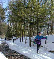
GOAL: Increase recreational opportunities throughout
the subbasin.
- Support the Wachusett Greenways group in its volunteer
efforts to link communities via multi-use intermunicipal trails
and open spaces, and in particular the Mass Central Rail Trail.
- Improve canoeing, fishing, and swimming opportunities
by removing weeds from water bodies and educating the public about
the spread of invasive plants*.
- Educate municipal departments (especially Public
Works Depts.) on efforts relating to invasive species*
identification and removal.
GOAL: Improve water quality in the basin.
- Conduct more detailed inflow/outflow studies given
stressed status of some waterways.
- Encourage Town of Sterling to apply for state Aquifer
Land Acquisition funds to acquire land adjacent to town wellfield
(if appropriate to town).
- Identify the major sources of fecal coliform and
nitrate-nitrogen inputs to the river and work with communities
to address the problem.
- Assist the municipalities of Holden, Leominster
and West Boylston in implementing EPA's Phase II stormwater requirements.*
These municipalities will be required to obtain permits to reduce
impacts to the receiving streams through the development of Best
Management Practices (BMPs)*,
elimination of cross-connections and significant public education.
CSO controls and the development of a long-range control plan
will be required.
- Identify the degree of threat from potential faulty/
illicitly discharging septic systems, which may result in bacterial
and nitrate contamination of nearby streams and groundwater.
- Identify underground storage tanks (USTs) and work
with communities to have them removed.
- Monitor effects of increasing urbanization to prevent
diminished groundwater recharge and to declining stream flow as
well as stream channel widening and downcutting.
- Help develop and disseminate) Best Management Practices
for small-scale, hobby type agricultural operations.
GOAL: Reduce negative effects of development in
this subbasin.
- Monitor uncontrolled runoff from construction sites
to prevent sedimentation of streams.
- Track increased imperviousness and both direct
and indirect riparian zone alterations that may increase stream
temperature and cause sedimentation.
- Help local volunteer board members responsible
for development and land-use rulemaking and enforcement get technical
assistance and information regarding fundamental and innovative
techniques to control and guide land use and development balanced
with adequate resource protection (e.g., Citizens Planner Training
Collaborative10 workshop offerings).
- Increase or establish staff hours of municipal
conservation agents to more effectively monitor runoff from construction
sites and assist with the preparation of relevant bylaws.
- Write and implement stormwater, erosion,
and sedimentation bylaws/controls.
back
to top
|