|
Geographic
Overview and Ecosystem Characteristics:
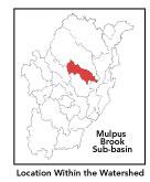
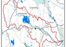
This subbasin1
predominantly lies in the community of Lunenburg and Shirley, with
a portion extending into Townsend. Located in the Southern New England
Coastal Plains and Hills ecoregion2
of central Massachusetts, this area drains into the mainstem Nashua
River just downstream of the Devens Wastewater Treatment Facility
and opposite Moore Airfield on Devens North Post. Mulpus Brook has
its headwaters in the northwestern portion of Lunenburg and is impounded
behind Hickory Hills Dam (as well as several beaver dams throughout
its length). Streamflow, as in most of New England, has significant
seasonal changes3.
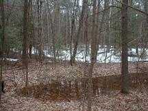
Beaver Pond Brook is a feeder stream to Mulpus Brook. A well-defined
ridgeline defines the western boundary of this subbasin. Route 13,
2A and 225 travels through this subbasin.
back to top
Land Ownership and
Land Use4
Patterns: The land-use pattern is 68%
forest (hardwood mixed with softwood) or wetland. Low-density residential
settlement as well as concentrated settlements and strip development
along major roads and in subdivisions account for 12% residential.
8% of total land area is agricultural. Commercial operations, industry
and other developed land uses are numerous particularly along Route
2A.
7.3% of this subbasin is impervious surfaces5
-- namely, paved areas such as streets, driveways, and parking lots
- which indicates that issues of compromised stormwater and other
non-point sources of contaminants6
(for example: pesticides, fertilizers, oils, asphalt, pet wastes,
salt, sediment, litter and other debris) are not an immediate pressing
concern.
A shoreline survey of Mulpus Brook in Shirley
was conducted by the Shirley Greenway Committee in the Fall of 2000.
Although several problems were noted including a septic discharge
situation at a mobile home park and sedimentation build-up at various
road crossings, the brook was generally described as having a good
buffer and being of high quality.
back to top
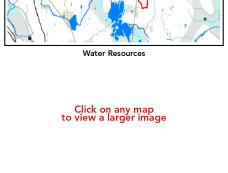
Major Water Resource
Issues: There are neither any wastewater
treatment facilities, NPDES* permits, nor Water Management Act (WMA)*
water withdrawal permits in this subbasin. Polluted runoff and sedimentation
is an increasingly serious issue in rapidly developing communities.
A small area underlying Hickory Hills Lake is classified as a medium-
and high-yield aquifer. The major waterbody in this subbasin is
Hickory Hills Lake (a.k.a. Dickinson Reservoir), which has been
noted for having elevated mercury concentrations in its largemouth
bass7.
Feeder streams to Mulpus Brook include various unnamed ones, which
constitute its headwaters and Beaver Pond Brook, which has its source
in a wetland at the western base of Chaplins Hill in Shirley (and
is owned by the town Conservation Commission). There is a wetland
complex at the confluence of Beaver Pond and Mulpus Brooks at the
base of Deacon Hill (which is owned by MassWildlife).
Based on recent findings in an Hydrologic Analysis
(inflow/outflow) by Camp, Dresser, McKee, under contract with EOEA
for the Massachusetts Watershed Initiative Nashua Team, the Mulpus
Brook sub-basin is currently under a medium level of stress. Looking
ahead to 2020, the Mulpus remains under a medium level of stress.
This means that the net 7Q10 outflow from the sub-basin equals or
exceeds the estimated natural 7Q10. 7Q10 is the lowest consecutive
7 day streamflow that is likely to occur in a ten year period in
a particular river segment.
back to top
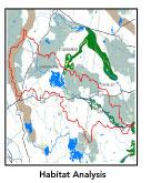
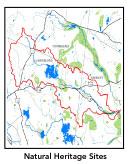
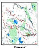
Recreation and
Priority Habitat Areas: Marshall Park
in Lunenburg is a local recreation destination. Lunenburg Town Forest,
the municipal Cowdry Nature Center, and Hunting Hills Wildlife Management
Area (WMA) in Lunenburg and Mulpus Brook WMA in Shirley are the
largest contiguous blocks of conservation land in this subbasin.
There are several state-designated Natural Heritage and Endangered
Species Project (MA NHESP) Priority Habitat areas which are also
Rare Wetlands Wildlife areas including: a wetland site by Marshall
Park and North Cemetery; another Lunenburg site is in the extensive
marsh just below the outlet of Hickory Hills Lake; another Shirley
site is by Mulpus Road near Hunting Hill Road; and one other Shirley
site is along Mulpus Brook just upstream of its confluence with
the Nashua River.
The one habitat protection focus area identified
in the Nashua River Habitat Assessment Report (MAS, 2000)
follows the lower half of Mulpus Brook proper, that is, for its
entire length throughout Shirley. The four habitat protection focus
areas in this subbasin are: Mulpus Brook, Pearl Hill Brook, Squannacook
Hill, and Willard Brook State Forest. Protection priorities include
the riparian buffer for Mulpus Brook near Brattle and Squannacook
Hills in Shirley. The whole subbasin serves as an east-west link
from the Worcester Plateau highlands to the Nashua mainstem lowlands
in Shirley and Groton and as a crucial steppingstone for wildlife
movement towards the large Oxbow/Intervale/Bolton Flats core area.
back to top
Resource Protection
Goals and Recommended Actions
GOAL: Protect wildlife habitat
and migration corridors in the subbasin.
- Land protection efforts to focus on undeveloped
parcels along Mulpus Brook upstream of Hickory Hills Lake as well
as the undeveloped portions of Maplewood Golf Course.
- Sponsor local events to raise public understanding
about native wildlife and the impacts of development patterns
on ecosystem and habitat integrity.
- Work with local conservation commissions to gain
their backing of natural resource and habitat inventories.
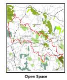
GOAL: Protect high-priority open space, vistas,
and community character in the subbasin.
- Encourage the use of MA Executive Order 418* funding
for Open Space and Resource Protection Plans for each Massachusetts
community in this subbasin.
- Conduct public education sessions to promote local
passage of Community Preservation Act*.
- Support efforts of the Squannassit Regional Reserve
Initiative* (facilitated by the NRWA) and the Squannassit ACEC
nomination which encompasses much of this subbasin.
- Work toward ideal of at least 25-50% protected
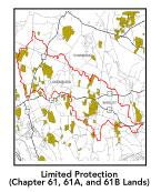
open space in each municipality. . Determine which Chapter 61,
61A and 61B properties to pursue Right of First Refusal* options
on if the opportunity arises. Apply for Division of Conservation
Services Self-Help funds* for appropriate properties.
- Work with municipal officials to develop subdivision
standards that require proponents to devote at least 50% of land
(not including already undevelopable wet or steep land) for open
space conservation and encourage mixed-use development and cluster
zoning by-right bylaws.
GOAL: Increase recreational opportunities throughout
the subbasin.
- Improve canoeing, fishing, and swimming opportunities
by removing weeds from water bodies.
- Educate the public and municipal departments (especially
Public Works Depts) on efforts relating to invasive species identification
and removal.
GOAL: Improve water quality in the subbasin.
- Assist Lunenburg with its Clean Water Act mandated
Phase II Stormwater requirements*. Lunenburg will be required
to obtain permits to reduce impacts to the receiving streams through
the development of Best Management Practices (BMPs)*, elimination
of cross-connections and significant public education. CSO controls
and the development of a long-range control plan will be required.
- Work with Hickory Hills Lake Association: 1) to
educate lakefront homeowners about non-point sources of pollution
and 2) in their efforts to survey and address invasive plant infestation
on Hickory Hills Lake.
- Inventory, monitor and improve stormwater drainage
structures.
- Identify underground storage tanks (USTs) and work
to have them removed.
- Help develop and disseminate Best Management Practices
for small-scale, hobby type agricultural operations.
GOAL: Reduce potential negative effects of some
development in this subbasin.
- Review the turf maintenance practices of area golf
courses up-gradient of Mulpus Brook's headwaters to determine
potential non-point source pollution from fertilizer use.
- Help local volunteer board members responsible
for development and land-use rulemaking and enforcement get technical
assistance and information regarding techniques to control/guide
land use and development balanced with adequate resource protection
(e.g., Citizens Planner Training Collaborative8
workshop offerings).
- Increase or establish staff hours for municipal
conservation agents to more effectively monitor construction sites
runoff and assist with the preparation of bylaws such as erosion-sedimentation
controls.
back
to top
*
See glossary.
|